


Outdoor Südtirol
Mô tả của Outdoor Südtirol
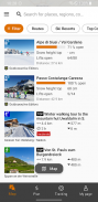
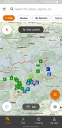
Tìm kiếm theo địa điểm hoặc kích hoạt vị trí của bạn để khám phá các hoạt động lân cận. Lọc kết quả dựa trên sở thích của bạn và khám phá bản đồ để tìm những kết quả mới. Đặt kết quả ở dạng danh sách để xem ngay mô tả ngắn gọn.
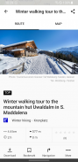
Bạn có thể nhận được mô tả chi tiết, thông tin kỹ thuật, bản đồ và chỉ đường GPS mà bạn thậm chí có thể lưu vào ngoại tuyến cho các hoạt động ngoài trời vào Mùa hè và Mùa đông của mình ở Nam Tyrol.
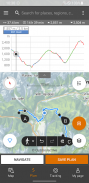
Bạn cũng có thể tạo hành trình tùy chỉnh:
- lập kế hoạch hành trình của bạn trực tiếp trên bản đồ của ứng dụng
- ghi lại tuyến đường của bạn và thêm ảnh và mô tả
- chia sẻ hành trình yêu thích của bạn với bạn bè để lên kế hoạch cho chuyến phiêu lưu ngoài trời tiếp theo của bạn ở Nam Tyrol và Dolomites
Khám phá nhiều tính năng hơn nữa!
Quan trọng:
Sử dụng ứng dụng trong nền với GPS của bạn được kích hoạt có thể làm giảm đáng kể tuổi thọ pin.
Outdoor Südtirol - Phiên bản 3.17.8
(10-09-2024)Outdoor Südtirol - Thông tin APK
Phiên bản APK: 3.17.8Gói: it.bz.smgPhiên bản mới nhất của Outdoor Südtirol
Phiên bản khác


Ứng dụng cùng danh mục


Bạn cũng có thể thích...


